the spirit of the king of aussie country lives and breathes in the annual tamworth country music festival.
slim dusty looks down on aussie country superstar lee kernaghan’s performance at tamworth country music festival
two weeks a year, at the height of summer, outback australia lives a fairy tale called tamworth. the ghost of slim dusty rises from his grave singing songs every aussie country music fan knows by heart. parents bring their kids, kids bring their parents, families reunite in caravan parks and dingy motels to revisit and revive the music that made them aussie.
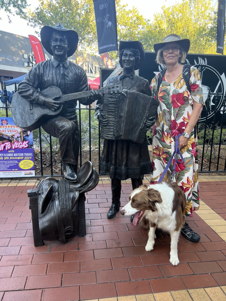
more than two decades after his soul passed into country music heaven, slim dusty’s aura still pervades the many stages and sidewalks of the tamworth country music festival. buskers lining peel street, tamworth’s CBD (aussie for central business district) , cover slim dusty classics, and if they’re old enough to have known the great one, spin yarns of their encounters with him and how he affected their career paths. in the sacred center of peel street stands a statue of dusty and his partner in life and song, joy mc kean.
from left: slim, joy, billabong and pernille pose on peel st.
tamworth is small town australia. neat, orderly, law-abiding, church-going, family-oriented, friendly. for fifty weeks a year, there’s not much to distinguish tamworth from dozens of other tidy communities that dot the countryside of new south wales, west of the great dividing range that separates bush country from the coast, where the great majority of the population lives. but for ten days every january, tamworth transforms into the capital of australian country music, a genre that captures the hard-working, hard-drinking, god-fearing spirit of the aussie bush. here, slim dusty is next to god. or maybe, IS god.
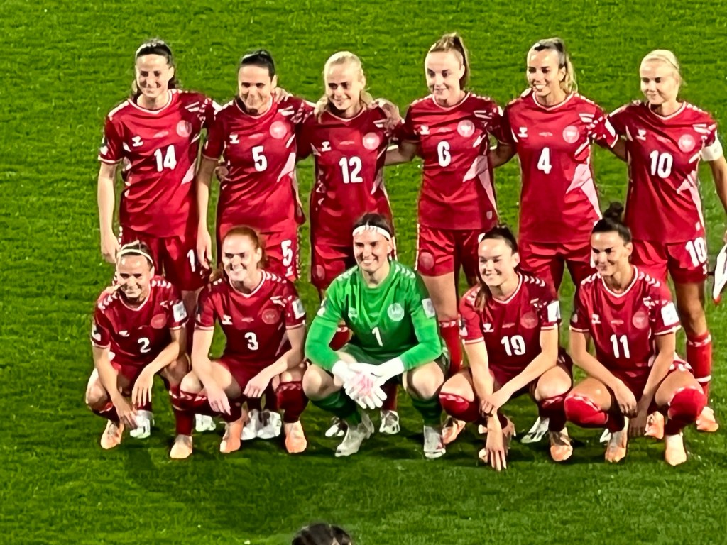
this year’s TCMF, as it’s called, featured some of australia’s biggest country music stars in concert, with lots of “guest appearances” by the big name performers at each other’s shows. troy cassar-daly and lee kernaghan, two of the genre’s veterans, filled the four-thousand seat tamworth regional entertainment and civic center (TRECC) on consecutive nights, doing a cameo appearances at each other’s concerts. they joined forces for a cover of a slim dusty classic written by joy mckean in 1972.
these TRECC concerts were sellouts , but at AU$65 to AU$75 (maybe US$40 or so) a seat, they’re not the main attraction for the estimated 300,000 country music fans who visit the festival each year. most folks come for a free peek at aussie country music’s future. of the big names we saw in concert, almost all stumbled over themselves to tell stories of starting out busking the streets of tamworth, playing for spare change from passersby. some of the best of this year’s crop were stevie wright, a nine-year old keyboardist who we saw doing an impressive cover of lynyrd skynrd’s 1970s classic “simple man”, and wade forster, a mustachioed youngster wearing a hat four sizes too big for his head, who won the “toyota starman” competition. wait 20 years, these will be tamworth’s headline names.
stevie wright, age 9, sings “simple man”
wade forster, sporting the hat he’ll be wearing when he hits the big time
peel street is a buskers jungle during the festival. walking along the avenue is like scrolling across an AM radio dial, moving from one musical orbit to another. it’s momentarily jarring as one song fades out and another fades in. but it rocks if you let it.
down peel street we wandered to town hall on saturday morning, the final day of the festival, to see “fanny”. we hadn’t a clue beforehand, only tickets purchased online for “fanny at town hall . town hall isn’t a premier venue, but fanny and her band blew us away. “fanny and the prawnstars”, all (except fanny) wearing red jumpsuits, could have been mistaken for inmates at the local jail. (convicted of “prawnography”, i suppose.)
fanny’s a farm girl from tooma, a tiny community 600km from the nearest city, and she connected with the farm families who filled the hall from the moment she pranced onto the stage. afterward, home girl fanny (who was born margaret edwina lumsden) led fans to the back of the hall where she posed for selfies and signed autographs until the last fan had gone.
fanny-fan selfie
later that night, at the “golden guitar” awards ceremony, fanny won for best album of the year. she got a standing ovation from the fans at TRECC. later this year, we hear, she and the prawnstars are touring the u.s. (keep an eye out, americans. you’re in for a real treat)
the next day, tamworth rolled up the signs, the artists packed up their gear, and the fans melted back into their daily lives ploughing the red earth in outback australia, west of the great divide. bush country.
they say the world cup competition is for losers. thirty-two teams compete, 31 lose. one–spain in this case– takes the cup and goes home for four years. the 2023 pageant was held “down undah”, in australia and new zealand. it’s the first time the competition has been co-hosted by two countries. too bad only one could win.
the previous two women’s world cups had been won by the u.s., as the rest of the world’s women caught up. but the catching up is done, and the americans’ moment is over. the “red, white and blue” barely survived the group stage this time, and made an unceremonious exit in the first knockout round, denying megan rapinoe and company a fond farewell from the competition they dominated for the past decade or so. now it’s the spanish womens’ turn to rule. this year the spaniards won the world’s under 18 competition, the under 21 tournament, and now the big one — the women’s world cup.
“travel soccer” is a term many moms and dads learn when their kids try out for the neighborhood team. the coach of the team then enrolls them in a league where they go to the home fields of other teams to play their matches. so parents usually wind up spending their weekends carting their beloved offspring to farflung neighborhoods to watch them chase around a soccer ball. in a country the size of australia, traveling to see your team’s world cup matches can mean splurging the family fortune on transcontinental air fares and winding up with a bad case of jet lag.
and so it was.
the danish women didn’t really have a chance to win the title in this women’s cup 2023 competition. but who cares? the object is to have some fun, root for your team and country, travel a bit (in this case, a lot!) and pay qantas (the airline) a few more bucks you didn’t have in the first place.
fortunately, (i suppose) denmark’s matches were all in australia, but oz is a big place, and we were following the women in red to the match sites. first perth, on australia’s southwest coast, where the danes played their opening match against china. it was a slow contest, though not nearly as time consuming as the 4 ½ hour flight from canberra to perth.
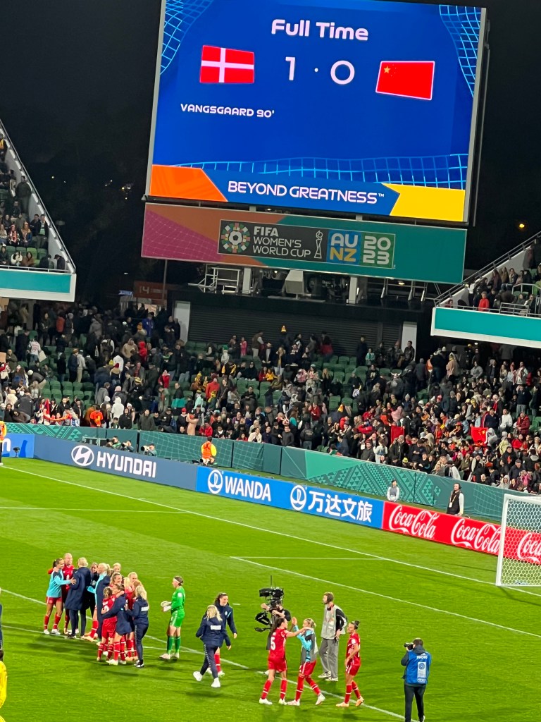
denmark finally scored a goal in the 90th (last) minute of regulation time to defeat the chinese women and secure the three points that went with it. so much for excitement.
a goal in the 90th minute separated denmark and china
among the highlights for us was a meeting with two danish fans who were reunited for an 81st birthday celebration, several decades after one of them relocated from denmark to australia. sadly, we don’t have “before and after” pictures showing how little they’ve changed over the years (or not).
the “after” shot of 2 danish “ladies in their 80s” reunited in oz after decades on opposite sides of the globe.
the second “group stage” match was on the other (eastern) edge of the continent, against england, requiring another transcontinental (read five hour) flight to sydney. england was one of the ranked teams in the competition, boasting several players from the english women’s premier league. the lionesses, as the english women are known, were a class above the danes, scoring a goal early (from chelsea striker lauren james), then holding on to that for a margin that held up all night. three points for the limeys.
then the team flew back to perth again, this time to face haiti, their third group foe. it was too much for us. we watched on TV. another single goal against the haitians was enough to garner three more points, getting the danes to six (three points per victory, one for a draw). that result, coupled with a monster english victory over china, was enough to see denmark through to the round of 16, the knockout stage. three matches, two goals.
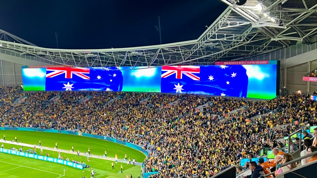
next opponent, however, was australia, in the first knockout round. facing the matildas, (from ‘waltzing matilda”, the national song), the tournament’s home team, was a daunting task under any circumstances. for the danes, playing in front of a sea of yellow shirted crazies at sydney’s 80-thousand seat olympic stadium proved an insurmountable challenge.
pernille’s red and white clashes with australia’s green and gold opera house
sydney was all decked out for the denmark match, with the (danish designed) sydney opera house dressed in australia’s green and gold for the event.
in the end, the danes total of two goals in four games was just not good enough. aussie striker caitlin foord, who plays club football for arsenal (my team) in the english premier league, scored an easy first half goal in a one-on-one matchup against denmark’s goalkeeper, and the danes were never a real threat to score. the matildas cruised, 2-0 (two-nil).
a double aussie flag celebrates one (or both) of the matildas’ goals against denmark
so much for travel soccer. the knockout stages are “win or go home” affairs, so it’s back to copenhagen for the red shirts, and an “end to the spend” on air fares. in the end the big fish (england & eventual winner spain) were left to battle it out for the cup. it was (extravagant) fun for us minnows in the world cup pond while it lasted, but there’s an end to every cinderella dream, and the clock has struck midnight. we’re pumpkins again.
p.s. on a sad note, it emerges that spain’s winning goal-scorer in the final, olga carmona, learned after the match that her father had passed away earlier in the day. the news had been withheld from her so as not to distract her during match preparations.
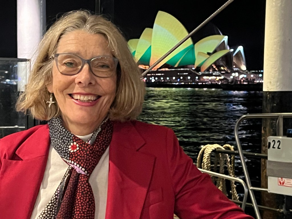
beneath the white sails, setting the record straight
good news, australia! forty-nine years after the opening of danish architect jorn utzon’s sydney opera house, the final touches are in place to make it possibly the finest facility of its kind.
utzon, who won an international design competition in 1957 with his vision of white sails billowing over the opera house, was sacked in 1966, after nine years of agonizing labor that had transformed a rocky point overlooking the city’s harbor into an architectural wonder.
a helicopter hovers over one of the eggshell “sails”, composed of perfectly geometrically aligned tiles
when utzon departed australia, never to return again, he left unfinished the nuts-and-bolts work needed to make the insides of the eggshells sing like the magnificent exterior he had so painstakingly constructed. after he left, the job was handed over to a three-man committee. in helen pitt’s comprehensive history of the controversial construction, entitled “the house”, she says it was like “asking three men to finish a rembrandt”.
the result left room for improvement. for more than forty years, performers and audiences whispered about the sound quality at the grand concert hall. it just wasn’t utzon.
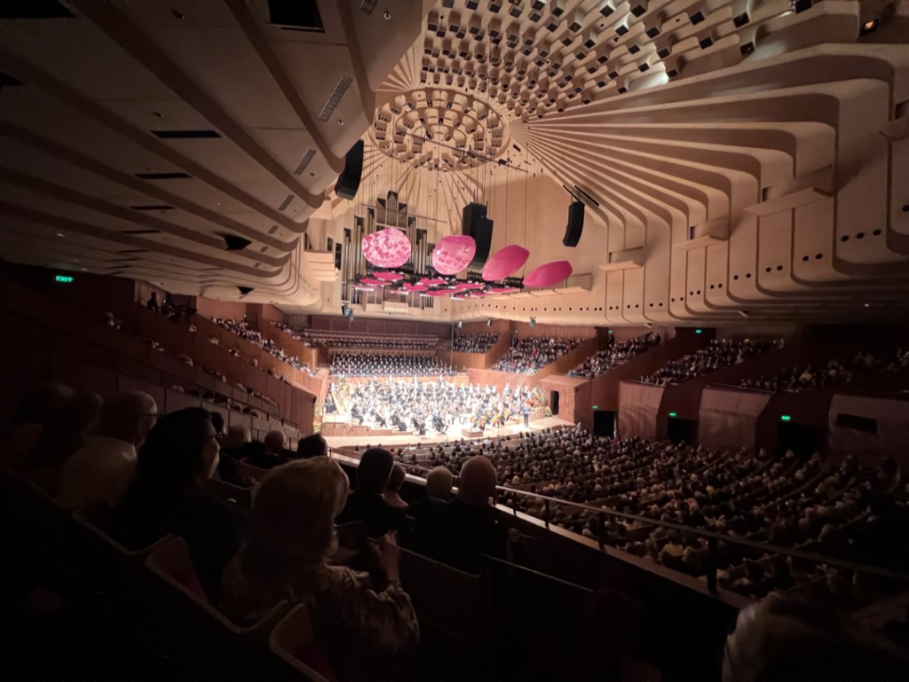
no longer! as the opera house prepares for its fiftieth anniversary next year, jorn utzon’s vision is complete. opera house c.e.o. louise herron, who spearheaded the upgrade, invited more than three-thousand faithful for a black-tie gala on july 21, 2022 for the grand reopening of the newly refurbished concert hall. she revealed in her program notes that, “the muller-b.b.m. acousticians, who worked on the philharmonie berlin and other fine concert halls throughout the world, regard this as their finest achievement.”
a packed house witnessed the opening performance at the newly refurbisheed grand concert hall
it shows!! the grand reopening featured the sydney symphony orchestra fittingly performing mahler’s “resurrection” symphony. it was preceded by a concerto written for the occasion by indigenous composer william barton, who incidentally is also australia’s leading didgeredoo player.
mahler’s “resurrection” is challenging music. under the baton of newly-appointed permanent conductor simone young, the orchestra shook the hall to its pre-fab concrete foundation in an epic performance. the capacity crowd rose to its feet in a roar of approval. the sydney opera house is now the global benchmark for excellence, inside as well as out.
a standing ovation from the packed hall
it was an evening that reflected australia’s growing self-esteem and stature. denmark’s ambassador to australia, pernille dahler kardel, was a special guest for the occasion. this was a night of righting the wrongs of history, in much the same way aussies have been doing with their aboriginal predecessors. jorn utzon, who died in 2008 at his home in denmark, was probably smiling from heaven.
the danish ambassador, flanked by opera house c.e.o. louise herron and new south wales arts and culture minister ben franklin.
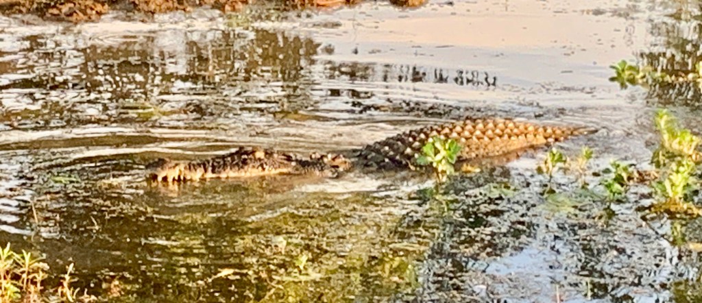
we seen a croc ‘r two in kakadu, and they been seein’ us, too
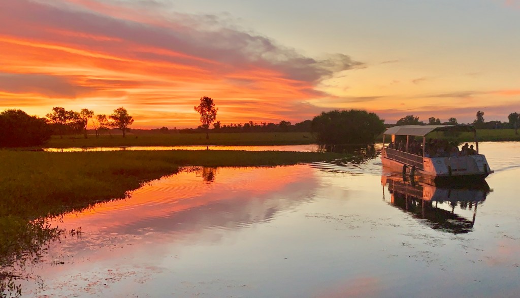
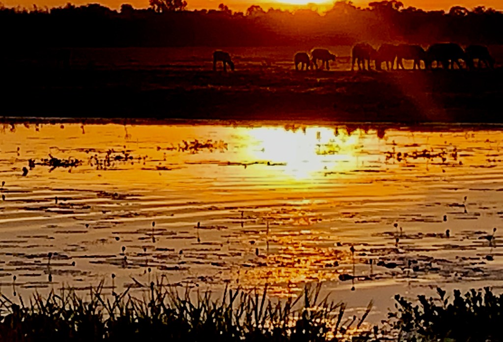
on patrol in the yellow water billabong
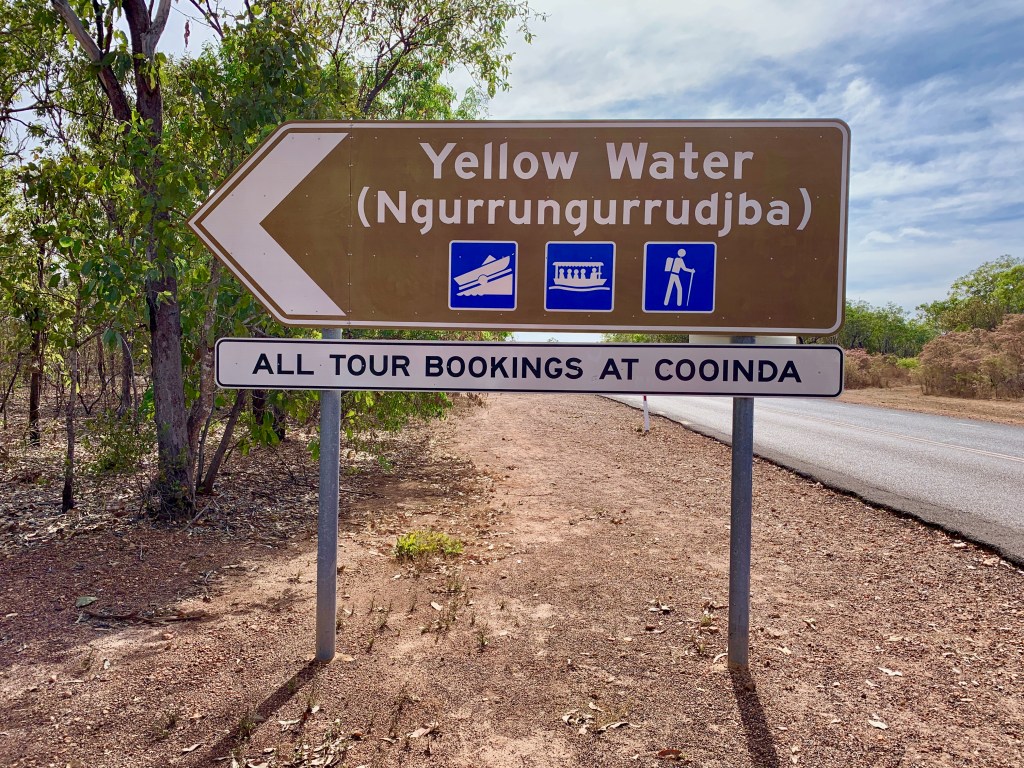
it took a while for us to figure it out. why would “yellow water” make the “must see” list of tourist attractions in australia’s northern territory ? “yellow water” sounds like a sewage pond.
certainly not a holiday to die for. maybe to die from.
my first thought when i saw the sign was, maybe it’s a warning. like “yellow fever region”? on second thought, maybe it’s a urinal, asking for contributions. maybe i could help out.
actually, the visit to yellow water, or ngurrungurrudjba in the language of the traditional owners of the land, the gagudju people, was possibly the highlight of our maiden visit to ‘the territory”. it’s a billabong in kakadu.
yep, ngurrungurrudjba is a billabong in kakadu. maybe a word of explanation is in order.
let’s take billabong first. it is several things. first, it’s an iconic aussie surfwear brand. it’s also a naughty four month old shoe thief who’s the newest member of the family.
billabong caught in the act
for our purposes here, though, billabong refers to the stagnant ponds that remain in river beds during the dry season, when the floodwaters recede. when the rains return, these billabongs overflow their banks and disappear into the flood plain that covers the lowlands.
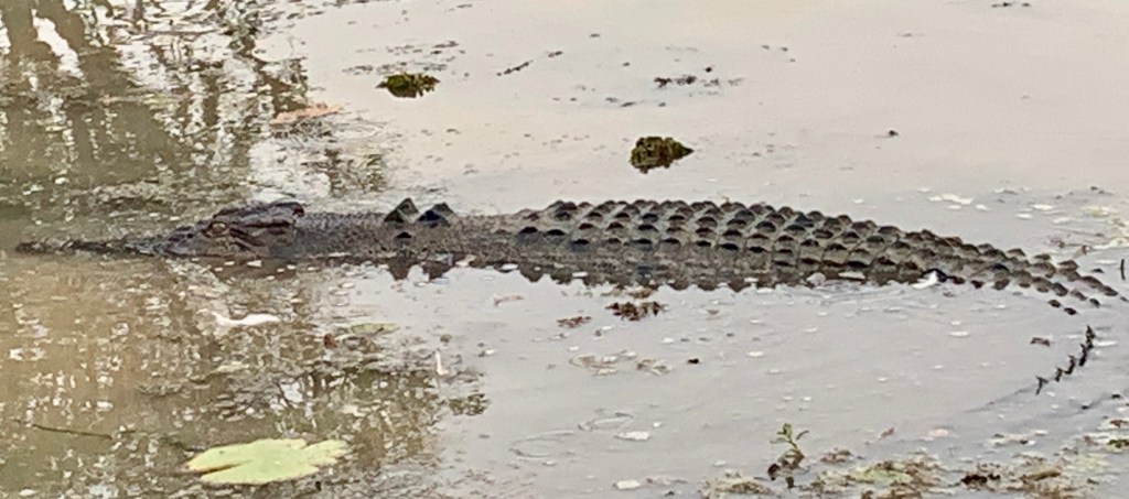
yellow water billabong is part of the south alligator river system, a peculiar name since there are no alligators in australia. only crocodiles. in the dry season, it’s just a big croc pond.
the n.t. (northern territory) is mostly “m-t” (empty)
kakadu is australia’s largest national park, home to the gagudjus, a wandering tribe that has inhabited these lands since time immemorial. it is a 20,000 sq.km. treasure trove of waterfalls, rain forests, dramatic escarpments, aboriginal rock art, exotic bird life, and the yellow water billabong.
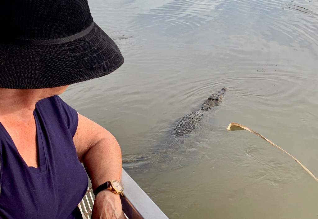
massive crocs glide by alongside cruise boats within arm’s length on the billabong, ready to snap off the limbs of anyone foolish enough to point. (“look ma, a crocodi…aaahh!”).
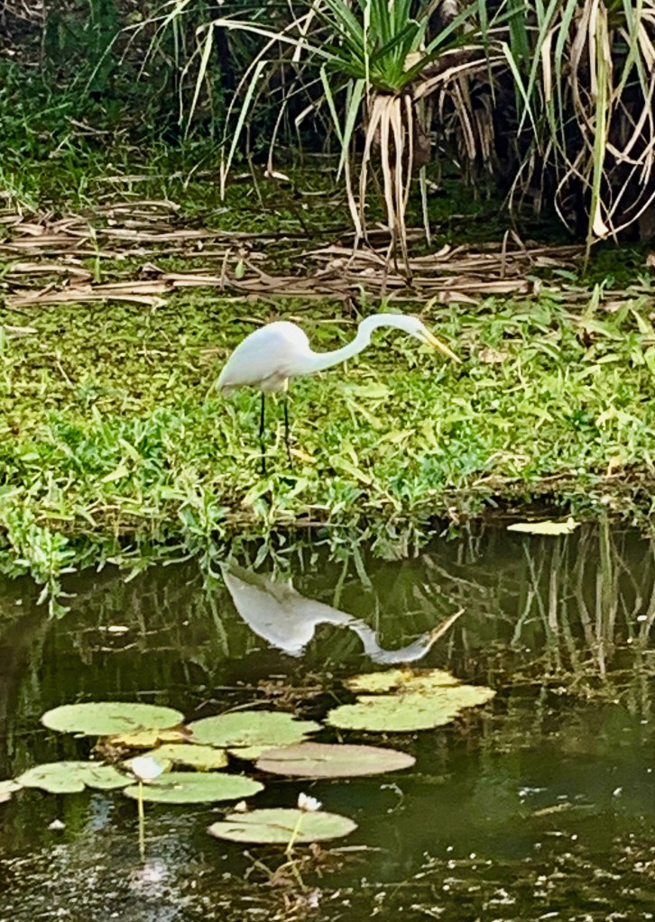
we were determined to see yellow water billabong even if we had to wear nose clips, because, frankly, we’d come for the birds. this billabong has been voted the #1 destination for birdwatching in oz! second place went to the alice springs sewage ponds in the southern northern territory, or “lower n.t.” in the local lingo. seriously!
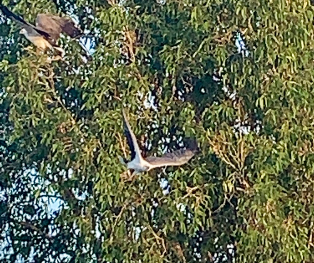
yellow water attracts roughly a third of australia’s 900 or so bird species. we saw white-bellied sea eagles, whistling ducks, white egrets, pied herons, magpie geese, night herons, azure kingfishers, black-necked storks and comb-crested jacanas, to name a few.
the birds were great. don’t misunderstand. but it’s a challenge to snap a high-resolution photo of a bird at 100 meters with the average cell phone camera. on the other hand, photographing a croc looking you straight in the eye presents the opposite challenge. it’s hard to fit them in the frame. you snap them, they snap you.
this 15 ft. (nearly 5 meter) croc kindly swishes his tail so it will fit in the frame
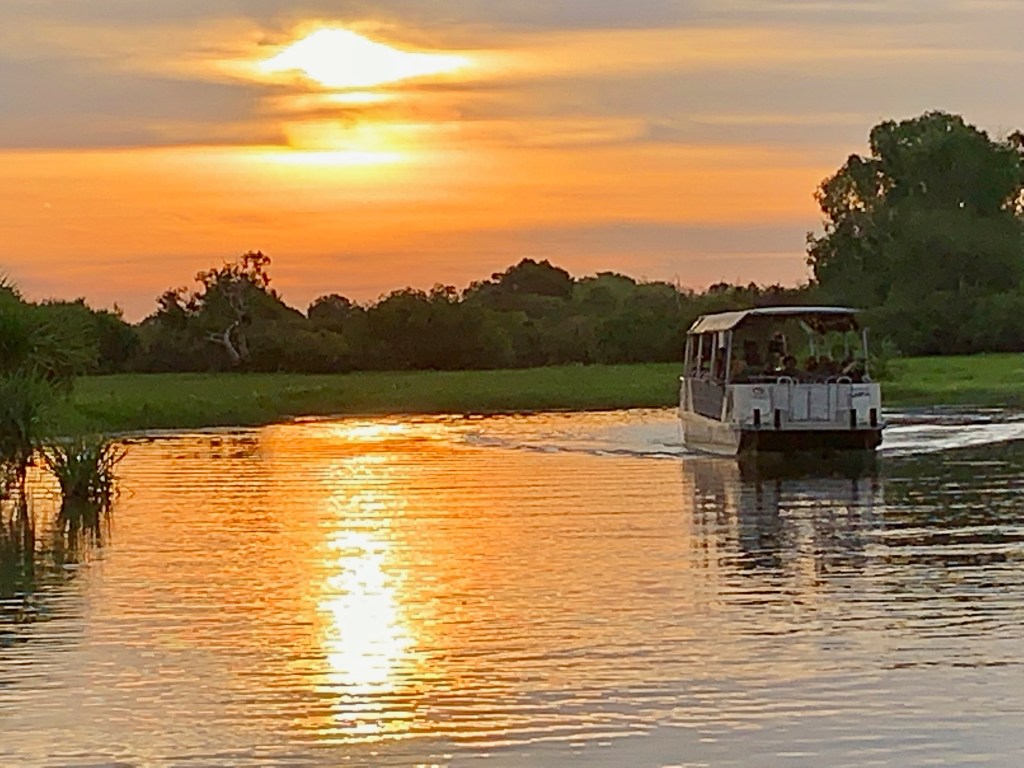
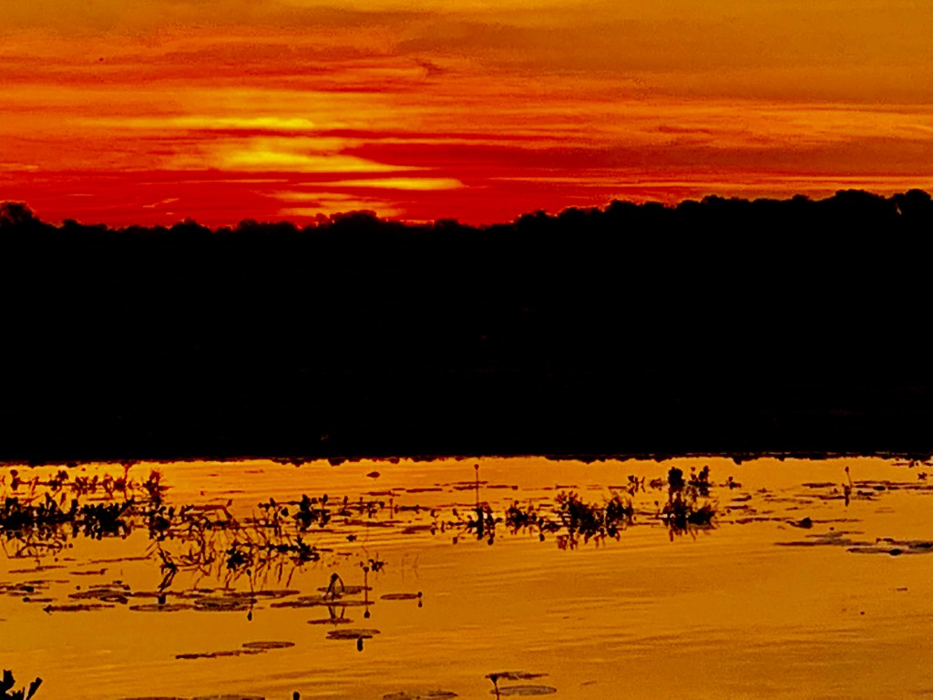
we had booked a sunset cruise at yellow water, then returned before dawn the following morning for a sunrise encore. both were excellent, but something was troubling. the birds were plentiful, the crocs suitably sinister, the weather ideal, the guides informative, the sunrise and sunset magnificent. but the water? yes, it was putrid. but it was… dull as recycled cardboard. a crocodile camouflage gray. what were we missing?
what had the gagudjus (pron: ‘ga-ga-jews) seen that we weren’t seeing? it was a real head scratcher. we didn’t get it until we returned home and downloaded our photos. there it was! yellow water! we’d seen the trees and missed the forest.
a cruise vessel on yellow water billabong at sunrise
the gagudju people had known what they were talking about. we’d been too busy looking at birds and crocs and water buffalo to notice the “ngurrungurrudjba”. duh!!
most of the day, yellow water billabong water is just a mud puddle crawling with creepy man-eating reptiles. but at dawn and dusk, it transforms into a golden pond crawling with creepy man-eating reptiles.
in our defense, we were only there two nights. for the gagudjus, this is the promised land. they know it intimately.
which comes first, human safety or crocodile safety?
they may not look gagudju-ish, but they’ve been wandering the desert and fishing this billabong for thousands of years.
and sure enough, the waters do part each year, allowing the tribespeople to walk across the sea bed, in keeping with oral tradition.
there’s no clear record of how the gagudjus coexisted with the crocs, who were probably there first. but the gagudjus live in harmony with the environment, which in the top end includes tropical heat, torrential rains, annual floods, (and no internet).
without a written language, the gagudju people passed down from generation to generation highly localized knowledge of weather and climate patterns. they identified six distinct seasons that are particular to the yellow water region.
the most welcome time of year they call yucky, spelled “yekke”, which ushers in the cool, dry months when the waters recede and the “balanda” (the gagudju-ish word for gentiles) arrive in their campers to inject a little cash into the local economy.
in contrast, the “balanda”, who stay mostly in darwin, observe just two seasons in the top end, which they call “the wet” and “the dry”. they also note the brief interim period when lightning storms illuminate the night sky to herald the change of seasons.
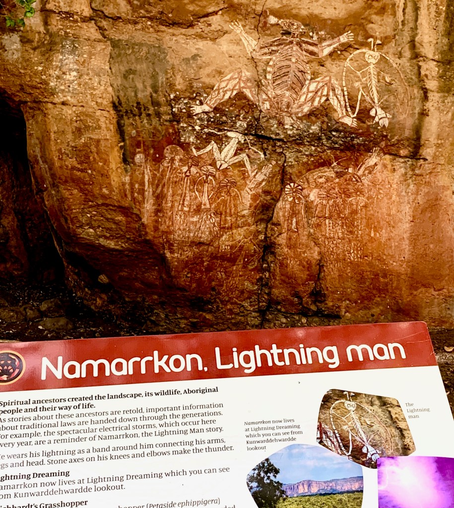
in gagudju lore, a powerful creation ancestor called namarrkon the lightning man shoots down from the heavens on a bolt of purple-white light with thunderous fanfare to deliver relief from the heat.
that’s namarrkon, at the top right of the wall painting
during “the dry”, the gagudjus camp mainly in the floodplain; but to paraphrase a line immortalized in song by two members of “the tribe” (lerner and loewe), “the rain, as in spain, stays mainly in the plain”, so during the rainy season the gagudjus move up to the stone country for shelter.
also, there ain’t no crocs in the rocks.
a painting in the park depicting an indigenous family on the move
before the balanda began settling the top end nearly two centuries ago, (mostly the west bank of the alligator river), the population of what is now kakadu national park was about 2000 people. that number has since dwindled to about 500, who maintain the sacred sites and preserve their ancestral culture.
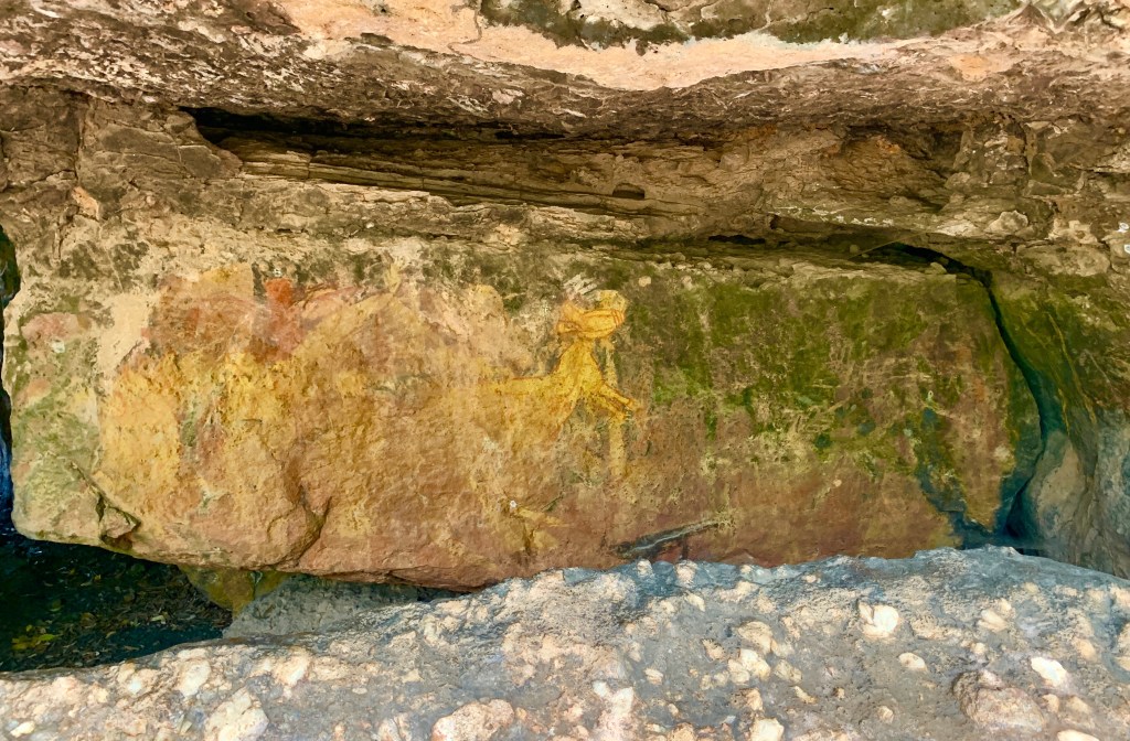
their mission includes preserving one of world’s greatest concentrations of rock art. some paintings are as much as 20,000 years old, making this one of the longest historical records anywhere.
nym djimongurr, photograph by valerie ihuede, c. 1970
many of the 5,000 artworks were spruced up and repainted by clan elders in a restoration project in the mid 20th century, as kakadu was coming to international prominence. much of the work was done by nym djimongurr, (pictured here), an elder who left behind a living record of his knowledge of gagudju-ish humor, stories and customs that provides visitors today with insights into bininj culture.
kakadu became a national park in 1979. in 1981 it was added to the list of world heritage sites. the unesco proclamation notes that kakadu:
“provides a window into human civilization in the days before the last ice age (and) reveals insights into hunting and gathering practices, social structure and ritual ceremonies of indigenous societies from the pleistocene epoch.”
almost any list of oz’s best national parks will rank kakadu #1. but it’s far from the most visited park. the most popular are those closest to sydney and melbourne. both have 20 times the population of the entire n.t.
like most of the top end, kakadu is practically “m-t”. “the territory” boasts a population density of about one person for every five square kilometers, most of them in darwin. by contrast, australia’s most densely populated region, the capital territory (canberra), has 150 people per square kilometer. (canberrans are quite dense.)
to understand just how remote the top end is, darwin is roughly a 45 hour drive (not minutes, hours) from any of australia’s big cities. it’s closer to jakarta than to sydney. getting to kakadu from sydney means a 4 ½ hour flight to darwin, then another three hours by car. so if you go, you can be pretty sure it won’t be crowded. (unless this blog post goes viral)
sunset from darwin’s bicentennial park overlooking the harbor
as a bonus, you can spend time in darwin, australia’s gateway to asia.
darwin’s status as a territorial capital is unique the n.t. is less autonomous than the country’s six states, and the people don’t seem to mind, partly because it’s virtually m-t, so there’s hardly any taxpayers. territorial status provides the n.t. most of the same rights and privileges as the states, but their administrative budget comes from the federal government. so by declining statehood, territorians can do whatever they please and let the feds foot the bill. they’re not that dense.
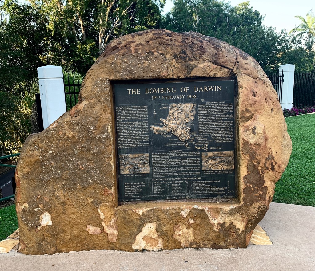
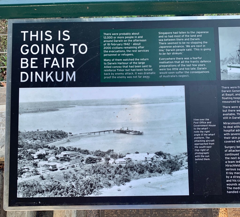
darwin is unusual in another respect. it’s been bombed. many times. it may be remote, but it’s strategically located on the timor sea. the same japanese planes that hit pearl harbor in december, 1941 turned their sights on darwin ten weeks later. they dropped twice as many bombs in the february 19, 1942 raids, killing 252 people. (damn near everybody there)
japanese bombers struck darwin 62 more times over the next 20 months.
the cenotaph war memorial at darwin’s bicentennial park
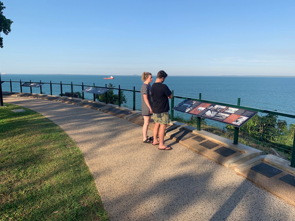
that bleak period is memorialized in a graphic display along the waterfront overlooking darwin harbor, where the bombs hit hardest. the city’s bicentennial park showcase the hardships endured during the period when all darwinians had one ear cocked for the sickening hum of incoming bombers.
it was “fair dinkum”, the locals said. “fair dinkum” is a catch-all aussie slang term. in this case, it seems to mean “this is not going to be pretty”.
darwin’s wartime history is outlined in a series of installations along the waterfront that bore the brunt of the bombs
bicentennial park serves as a reminder of darwin’s strategic importance, both in past military encounters, such as with japan, and the present, as the nation responds to an increasingly assertive china, which sees its backyard extending all the way to the australian shoreline.
the eternal flame in bicentennial park
darwin is, however, quintessentially aussie, as in directionally challenged. just as the australia’s south coast is on the east coast, the western most spot in the city of darwin is called… wait for it… east point.
that pales in comparison to what almost was. when australia became a federation in 1901, the north was part of the south. no one seemed to think it odd that south australia extended all the way to the north coast. eventually the southerners begged to be relieved of responsibility for the northern half because they couldn’t afford to administer it. there were no taxpayers there.
imagine the north coast being in the south
that’s it for year one. year two of the aussie adventure promises more road trips, as we’ve finally received our car. (it’s a beast) also, expect more adventures of billabong. he’s already practicing croc hunting.
billabong the croc hunter with his “catch”
we hope to include (covid permitting) a trip to uluru, in the southern northern territory. as the irreverent tourism slogan goes, see you in the n.t.
…and the lovable larrikin, a dog with a stick, and a cow with a telescope
it wasn’t exactly a state visit, but the ambassador of denmark to australia stopped for a “friendly chat” with the shire president of denmark, australia, in june to convey a brief message: “change your name, guys. we had it first”.
shire president ceinwen gearon was “not in” when the ambassador arrived, and kept the envoy cooling her heels in what might otherwise have been considered a diplomatic snub.
the president and the ambassador
but hey, this ain’t highfalutin’ europe, this is a back of beyond surfer town in west australia. the prez was at her day job at the local hospital. when staff called to tell her the ambo was waiting, she jumped in her van and zipped over to pose for pictures in her best jeans and housecoat. hell yeah! i mean, this is the wild west, and in oz that’s about a third of the country. or two thirds, depending on how you count.
the talks were held in the shire council chambers, where a portrait of the queen hangs on the wall. wrong queen. at least from the danish point of view. it’s the british queen. (that can be excused. australia is, after all, a member of the commonwealth)
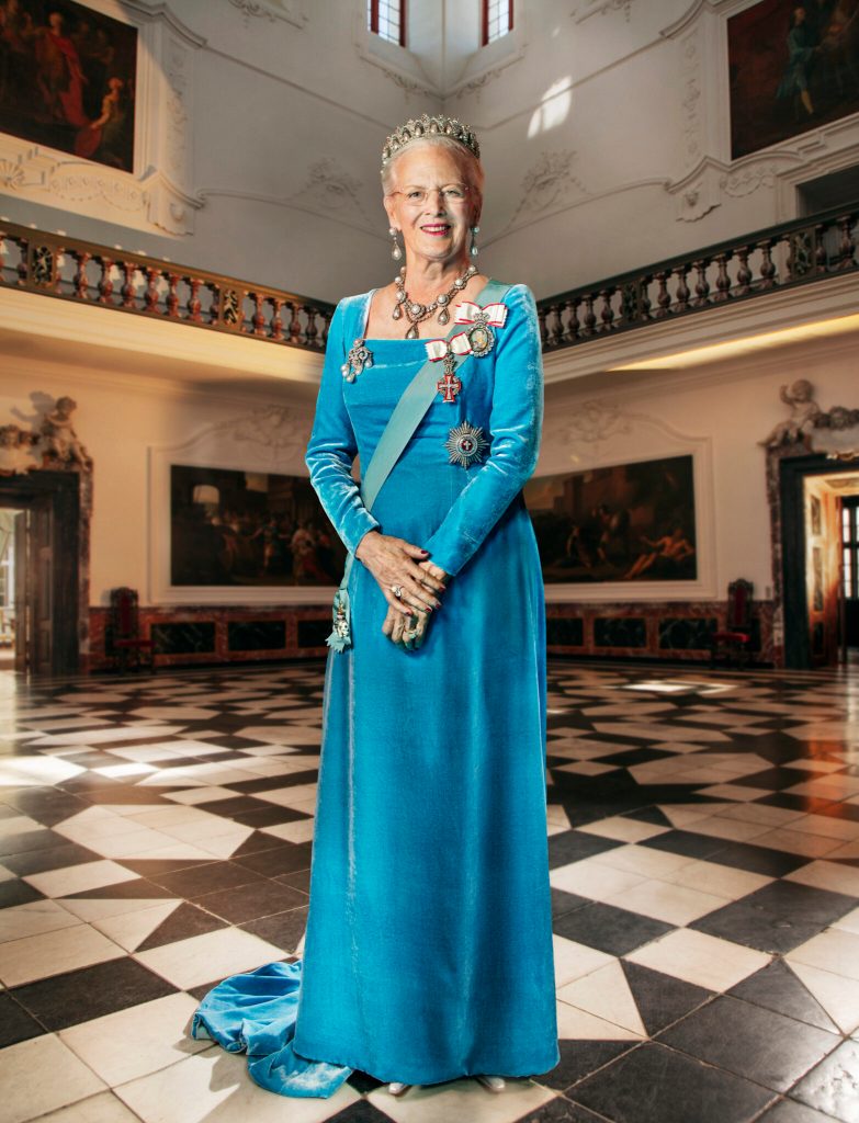
just in case they have a change of heart, however, the ambassador is sending over a portrait of denmark’s queen margrethe, which incidentally is strikingly similar to the portrait of queen elizabeth hanging in the council chambers. (no, the queen isn’t hanging. just the portrait)
queen elizabeth’s portrait
queen margrethe’s portrait
as for the name change request, it’s on hold. the town appears to have come by the name honorably, through an irish doctor whose family traces its roots back to a 7th century visit to ireland’s west coast by shipwrecked vikings, as honorable a bunch of rapers and pillagers as ever walked the earth.
interestingly, however, the good doctor never set foot in australia.
red dots denote the denmark region of the rainbow coast
dr. alexander denmark was a british navy surgeon at the turn of the 19th century, much beloved by a young hospital mate he trained as a physician. years later, that young man, thomas braidwood wilson, was exploring the south australian coast with an aboriginal guide, mokare, when they came upon a lazy stream mokare called kwoorabup. wilson, who was into naming stuff, decided to rename it the denmark river in honor of his old mentor.
over time, the region became known as the denmark district. decades later, when a permanent town was established where the river flows into “wilson inlet”, (which dr. tom named after himself,) denmark somehow won out over kwoorabup. the town’s namesake, meanwhile, lies in an unmarked grave back in england.
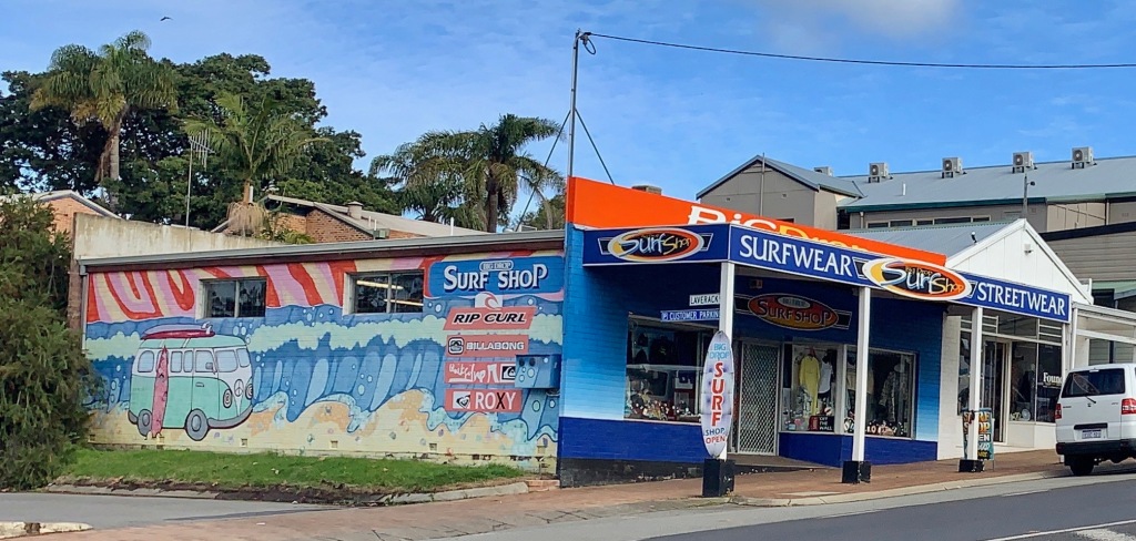
the denmark surf shop
denmark’s 25-hundred permanent residents (denmarkers? denmarxists? denmartians?) make a living mainly off the tourist trade. in summer, the shire balloons to several times its normal size as wave chasers descend on the “rainbow coast” seeking swells coming straight from antarctica.
even the prez keeps a board handy, and city employees work flexible hours so they can skip out when the surf’s up.
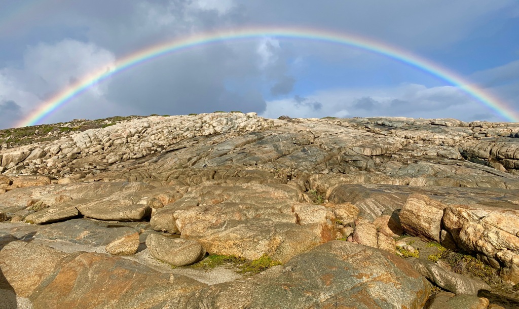
the coast gets its name because in winter, the low sun on the northern horizon combines with storms along the southern ocean coastline to create perfect rainbow conditions.
rainbow on the rocks – torndirup national park
on the morning of the winter solstice (22 june in oz) we drove east along the rainbow coast to torndirrup national park. we went for the spectacular rocks. what we got was a rock ‘n rainbow “two-fer” topped with an icy antarctic blast.
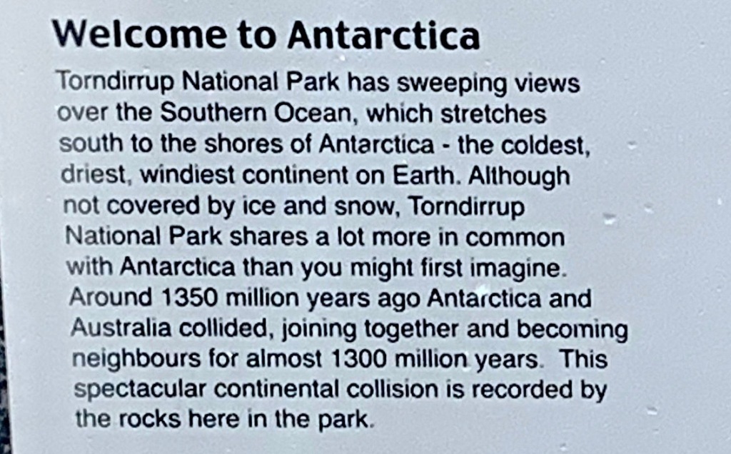
torndirrup bears witness to the long-term cohabitation of australia and antarctica (about 1.3 billion years). they only split up and went their separate ways about 50 million years ago. it seems to have been a messy breakup, and there’s no telling whose “fault” it was. it must have ugly, though, because the custody battle over several islands is still causing tremors, and a chill wind blows up from the south pole.
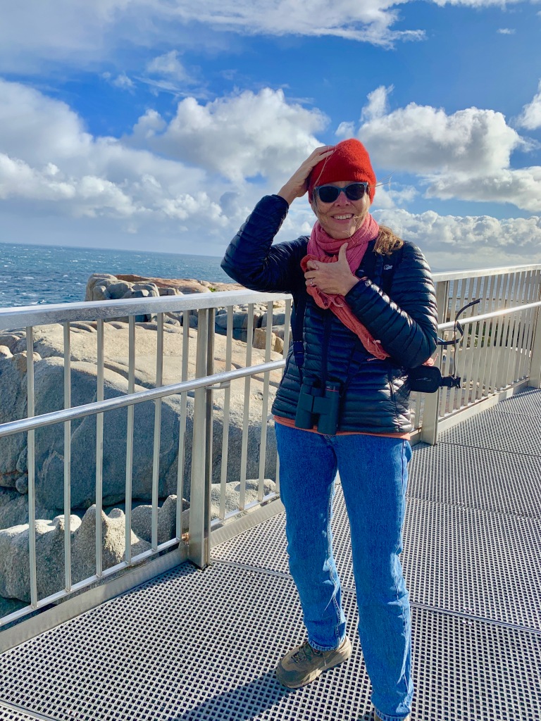
a wintry antarctic blast has pernille holding onto her hat
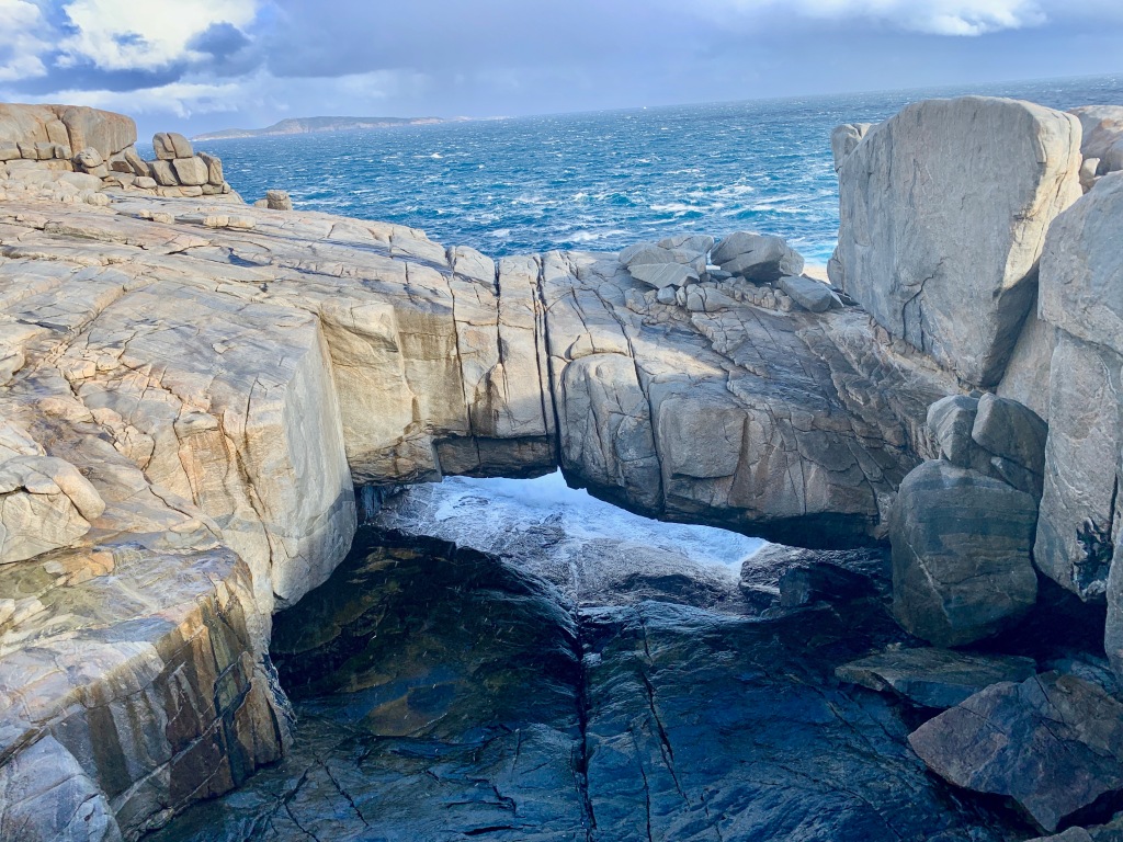
over the past fifty million years, the raw fury of the sea has left a ragged imprint on torndirrup’s coast, carving up granite like a thanksgiving turkey, one granule at a time, serving up its feast on tectonic plates. it’s a work in progress.
rock beach
natural bridge
the gap
for the moment, the main attractions are a natural bridge and a gash in the granite called “the gap”. but a transformation is underway, one eon at a time. we plan to drop by again in oh, say, ten million years to see what the artist has wrought. we can’t wait to see the time-lapse photos.
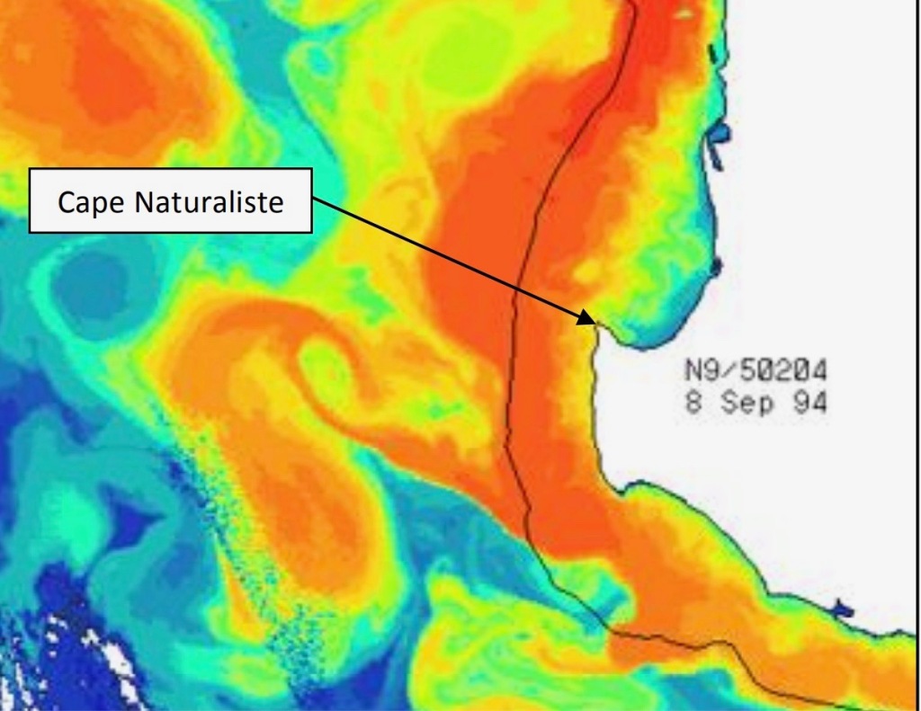
and since we can’t wait, we wend our way west from the wild wintry winds to the wonderful world of warm water waves and award winning wines. welcome to the magical margaret river region, the space between the capes. it’s a place of waves and grapes.
from cape naturaliste in the north to cape leeuwin in the south, the margaret river knob is 85 miles (135km) of divine coastline jutting out from australia’s southwestern corner, right into the path of a tropical ocean current that funnels warm-ish water (in red in the graph below) into the cape’s wave-grinder. the effect is most pronounced in winter. see the infrared water temperature shot at left. (red is warmest)
the red patch on the left is the warm leeuwin current, rolling southward along australia’s west coast
so on a chilly june evening, the margaret river beach is buzzing, as are the blanketed spectators snuggled together, toasting each other (and themselves) as wave dancers pirouette through the psychedelic proscenium arch.
the river mouth was the site of the world surf league’s margaret river pro competition in may, 2021
on shore, a blizzard of sundowners rages, while on the western horizon, the flaming orb gently slips beyond the waves. it’s rumored the “blizzard-enabled” can hear the hiss as flame touches water and disappears in a puff of smoke. pretty rad, dude.
we pause for a moment waiting for the credits to roll. then as orange fades to black, the audience retreats to the parking lot, hoping not to encounter a sobriety check on the road home.
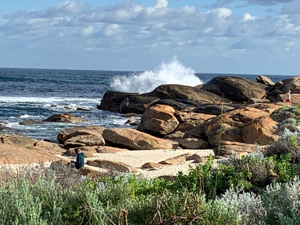
next morning, the thrill seekers are back. air temperature is about 50 fahrenheit, (ten celsius), and water temp about 68 (20 celsius). not bad for dead of winter this close to antarctica. we wander down to a rocky stretch of beach called redgate, just south of margaret’s mouth.
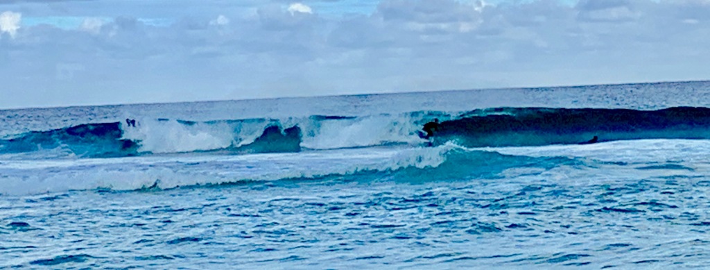
on this day the swells are relatively tame, but margaret river’s reputation for magical rides has made it an annual stop on the world surf league championship tour. with more than 40 world-class breaks, these are waves to die for. some have.
just south of the river mouth, amid the rocks of redgate, a grim reminder of nature’s power
the rocks at redgate bear witness to the power of the infamous rip currents that terrorize the cape’s wave riders. big signs warn of the danger. but on the morning of december 8, 2012, the signs were missing, apparently the work of vandals.
when two visiting americans paddled out from redgate beach that morning, lured by massive swells, they had no warning of the danger that awaited them. memorial plates embedded in the granite tell their tragic story
from the rocks it’s a two minute walk to the riflebutts reserve dog park, and as this blog is about to get very doggish, why not start here? it seems as if the augusta-margaret river shire council went on a sculpture binge around the beginning of this century, commissioning dozens of works. we ran across one on a morning jog through riflebutts.
“the stick” by russell sheridan at riflebutts park in redgate
many of the installations are noteworthy, but as we prepare to become parents of billabong the border collie, this one was irresistible.
not billabong, just a goofy hound with a stick
introducing the real billabong at 11 weeks old
it’s titled “the stick”. it’s the work of margaret river artist russell sheridan. a local sculpture website describes sheridan as “a larger-than-life character (who) memorably mythologizes the australian larrikin.”
larrikin? uh-oh, a new aussie-ism. turns out larrikinism is a time-honored australian tradition.
a history of the larrikin spirit written in 2012 calls it the key to unlocking the aussie identity: the lovable scallawag. its roots go back to penal colony times, when disdain for authority was a badge of honor.
but these days most aussies are coastal urbanites, a far cry from the hardscrabble convicts of two centuries ago. as the continent meekly complies with what others might consider draconian covid lockdowns, many are wondering whether the rough and tumble larrikin spirit is gone forever. steve waterson, writing in the australian newspaper, asks, “do we recalibrate our self-image, admit there’s no crocodile dundee left in any of us?”
truth to tell, oz is known more these days for water sports and wine. margaret river scores high on both counts.
don’t ask why, but one fine day, two wine ignoramuses got a hankering to go on a tour of the margaret river vineyards. (i mean, while we’re here…)
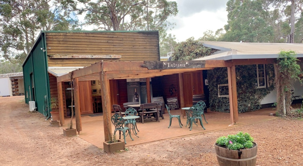
completely oblivious to reputations of various wineries, we simply typed into our GPS the name of a road where we had been told we’d find some “cellar doors”. when we came to that road, we turned right. a moment later we saw a sign that said “woody nook cellar door”, so we turned in.
the woody nook vineyard’s cellar door
the place looked deserted (middle of winter, you know) but the sign said “open” so we walked in. twenty minutes later we walked out the proud owners of a case of 2014 woody nook cabernet sauvignon.
wine and i have never gotten along, but this was lovely stuff. and it had a gold medal to boot. i have no idea how they hand out gold medals, (the writing is in french) but pernille serves vino at diplomatic functions, and the name “margaret river” with a gold medal on the label means wine about as good as you can get in oz, or anywhere.
back in the car, we proceeded to the end of the road, turned around and came back, passing a few more cellar door signs. it was vino roulette, where we stop, nobody knows.
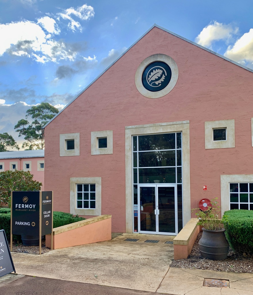
the fermoy winery in margaret river
as we drove, we suddenly had that feeling. turn in. it was a place that might have been an old barn somebody had painted pink, installed a glass front, and called a winery. we walked in to find a group of ‘tasters’ gathered around a table, sampling the wares. as we glanced over, something caught our eye.
on the wall behind them was a massive photograph. a bride and groom dancing. and a caption. “wine fit for a princess”. hey, wait a sec! we know that princess! that’s “our” princess mary, the aussie commoner who married the danish prince!
sure enough, this is the winery that produced one of the wines served at the wedding of mary donaldson and frederik, the crown prince of denmark, in 2004.
the result: another case of wine for our “cellar”. with a gold medal, too. maybe they sell these gold medal stickers at the local wine growers association. who knows. was it a great wine? don’t ask us. but it was pleasing to the palate (suddenly we’re connoisseurs). and what a conversation piece!
pernille laughed when i said we could visit three wineries in an afternoon. wine tasting and driving don’t mix. but on we went to a third, and a fourth, and even a fifth. it was getting toward sundown and everything was closing, but we did manage to buy a third case of wine.
somewhere.
it was called cherubino. we know that because it was delivered to our house a week later. and the debit was on our bank statement. it was a pricey afternoon.
fortunately, after all that tasting, we found my airport. it was right outside the last winery we visited. we must have flown home. and we greatly appreciate whoever delivered our car back to our b&b.
after a good night’s sleep, the next adventure was to the most southwestern point on the continent, cape leeuwin, where two oceans collide. (at least in the aussie version).
along the road we encountered a restaurant with a sense of humor.
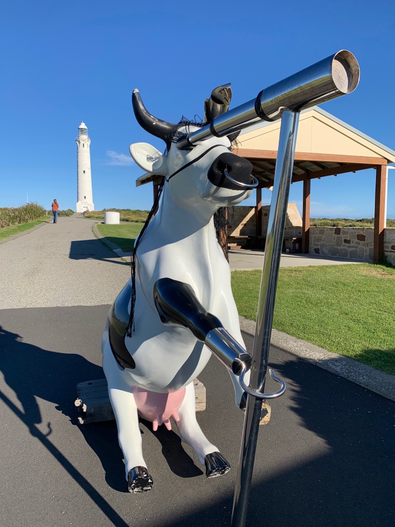
cape leeuwin is the site of the tallest working lighthouse on the australian continent. it’s also the home of a pirate cow holding a telescope with her hook. (real pirates have hooks, don’t they? and parrots on their shoulders, right? this one did.)
it’s hard to know what substances the augusta-margaret river shire council were ingesting around 2010 when they launched a region-wide “cow parade”. it seems to have been part of the same craze that produced the dog with the stick (above).
the cow parade was billed as the world’s largest public art event. cow art? at first i thought it was a typo, that they were in fact alluding to the bovine penchant for methane production. but no, these were supposed to be works-of-art. the “f” stays with “of”. “art” is separate.
the local tourism association apparently bought 80 or so methane-free (i.e. environmentally friendly) fiberglass cows and gave them to locals of artistic bent who volunteered to adorn them for display in various states of absurdity. despite the hail of udderly cheesy puns that followed, most of these “moo-sterpieces” were auctioned off after the parade to raise moola (cash) for local charities.
the pasteurized pirate, named “moo-rine the marauder”, eventually found a home at the lighthouse. several others migrated to cowaramup, a real life place in the capes region known as “cow town”. cowaramup’s website calls them “moorals”. (talk about milking a bad pun!)
it’s time to knock this off. pernille just came in in a bad mooood and said, “it’s pasture bed time”.
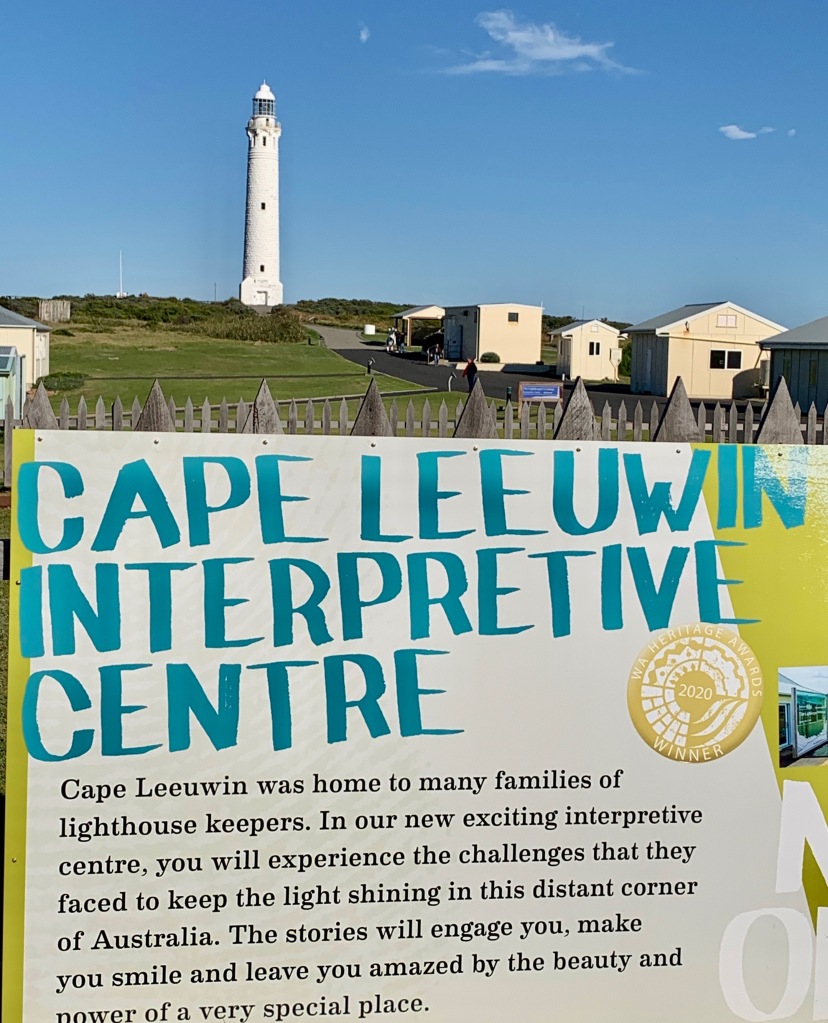
oh yes, the lighthouse.
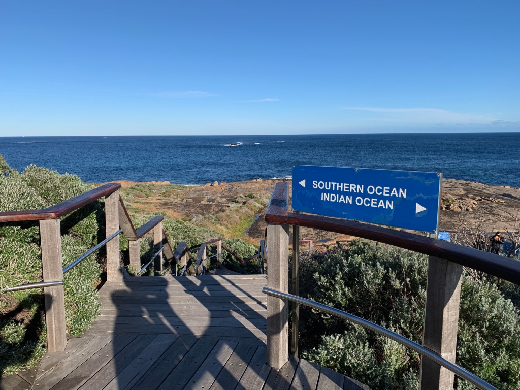
the cape leeuwin lighthouse and interpretive center sit at the most southwesternly point of the continent. signs proclaim this to be the meeting point of the indian ocean and the great southern ocean. on some days the smashup can be quite violent. on this calm and windless day it was little more than a surface splash.
some newfangled international maritime organization came along some time back and tried to redefine the southern ocean boundary so it no longer touches australia’s southern coast. the aussies aren’t buying it. the larrikin spirit rose up and told them to go stuff it. crocodile dundee lives!
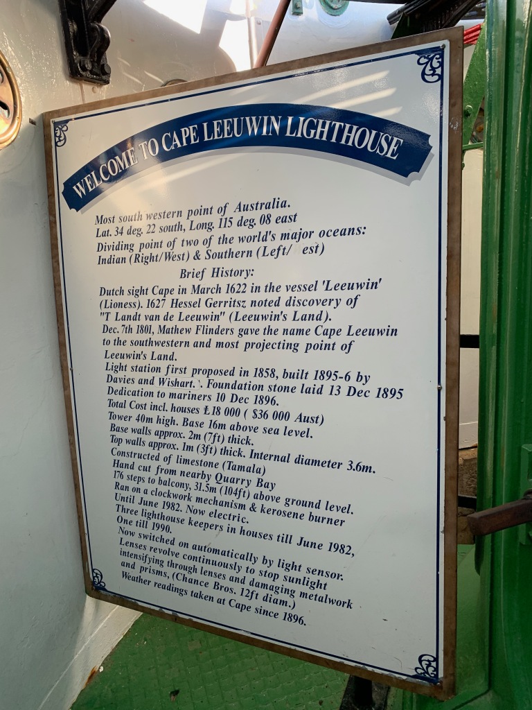
the cylindrical tower of the cape leeuwin lighthouse rises 39 meters (128ft.) from a square base up to an observation platform and a 100 million candle power halogen beacon that guides sailors around the treacherous cape.
the 100-million candlepower halogen lighthouse lamp
our plan was simply to walk the lighthouse grounds. we’ve been to plenty of lighthouses. but rowena, the interpretive guide lured us in, and we’re glad she did.
the tower’s 176 steps are a trip up through a time when the lighthouse was manually operated, originally using a kerosene wick lamp revolving in a mercury bath with a clockwork mechanism. it was the world’s largest kerosene lamp when the lighthouse opened in 1895, and could be seen for 40km.
for nearly a century, the facility was completely manually operated. three lighthouse keepers lived on the premises, so there was someone on duty 24/7/365 until it was converted to electricity in 1982.
lighthouse history
rowena the interpreter
an ocean over each shoulder
the clockwork mechanism, stanley kubrick would have painted it orange
after our lighthouse excursion, we went north to perth, excited to learn more about the west australian capital and oz’s fourth largest city. instead, we were given 24 hours to pack up and go home or face two weeks hotel quarantine. at our expense. we hightailed it to the airport. when it comes to covid, the devil-may-care larrikin spirit is overruled. crocodile dundee is in lockdown.
stay tuned. next episode we escape to real croc country.